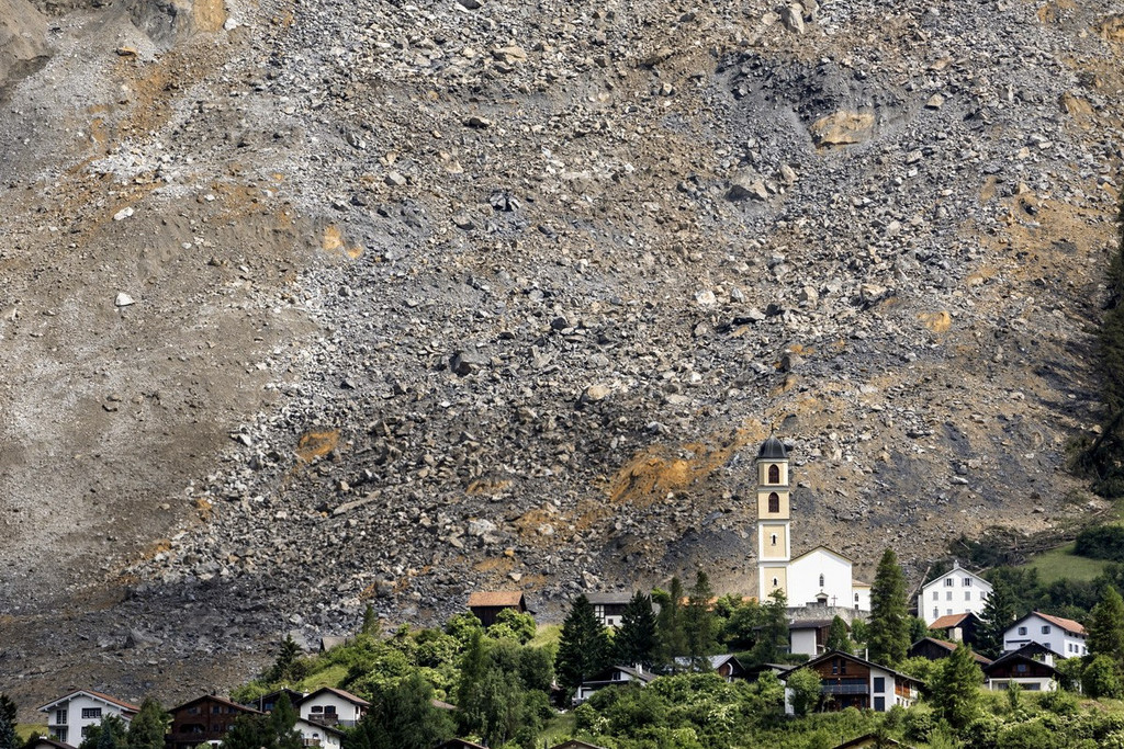
Perhaps there is a simple reason why Switzerland has not really lost its bearings for so long – its highly accurate national maps. Every stone, every prominent linden tree, every country lane and every rivulet are recorded. Especially now during the summer months, the painstakingly mapped country becomes a paradise for hikers. The notion that they all wear red socks is a daft cliché. But what is not a cliché is the fact that hiking has become one of Switzerland’s most popular recreational activities. The last major study on the topic indicated that 44% of the nation hike regularly. It is also true that the throngs of people on Switzerland’s network of hiking trails – which cover 65,000 kilometres and are marked with 50,000 signposts – continue to rely as much as ever on topographical maps, whether in printed or electronic form.
It is also the case that hiking in Switzerland is more a safe pleasure than an exciting adventure thanks to the outstanding maps. There is no patch of land where you can easily get lost in the unknown in this rigorously mapped country, as the unknown does not really exist.
2017 is a special year, and not just for hikers. Tribute is being paid to the beginnings of the art of Swiss cartography this year. Guillaume-Henri Dufour, who in 1838 set about the task of covering the country with triangulation points from French-speaking Switzerland and accurately mapping it, this year bears the title of “European surveyor of the year”.
Dufour set a very high standard
An honorary title 142 years after Dufour’s death? The tribute does not come too late, however. The many years that have passed simply highlight the tremendous accuracy of the first topographical maps of Switzerland, even from a current perspective. Dufour set the bar very high very early on. This explains why Swiss cartography continues to enjoy world fame today.
On the subject of world fame, At the “Exposition Universelle” – the 1855 world exhibition in Paris – Switzerland presented the proof copies of seven map sheets. Not much more of the nationwide project was actually available at this point. The jury nevertheless deemed it a “pioneering” achievement. The certificate for the “Medaille d’Honneur” awarded was signed personally by Napoleon III. The praise from Paris bore considerable weight as the French themselves had previously earned a reputation for turning cartography – which was beneficial militarily – into an art form. War and cartography went hand in hand. Victors must know the terrain. Swiss topographical maps were initially also intended for the use of army officers. However, in stark contrast to other countries, the exact mapping of Switzerland was never a military secret but instead a public – and aesthetic – project. The aim was to show how beautiful Switzerland was and to depict it in its entirety.
At that time there was no recreational pursuit society demanding navigational assistance. The popular pastime of “Landeskenntnis” (knowledge of the country) did not develop in bourgeois circles and crowded classrooms until the late 19th century. Initially, it was primarily the political elite of the Swiss Confederation who sought greater visibility for Switzerland, which had been conceived as a republic, as a step towards national unity. The thinking was that maps of the country do not just reflect reality, they also create it. They enable a common territory to be envisaged. The importance of the first maps of Switzerland in playing down differences and emphasising unity is illustrated not least by looking inside a wallet. When the first national topographical maps were printed, Switzerland did not even have a common currency.
Maps for nation-building
Dufour’s maps provided Switzerland with clear contours. This was ultimately his contribution to nation-building. Fridolin Wicki, the current Director of the Federal Office of Topography (Swisstopo), underlines the political importance of the early maps of the country to “Swiss Review”: “The diversity of the individual cantons disappeared in favour of national unity in the aesthetically produced maps.”
The nation’s enthusiasm for the work of its cartographers was highlighted by the national exhibition of 1883 in Zurich. The complete representation of Switzerland made up of individual map sheets was one of the main attractions. People continued to hold onto the fundamental belief that maps make it possible to envisage a country. Even in 1961, when the Federal Council approved the funding of a Swiss atlas, it declared that the initiative would produce an “intellectual weapon of Swiss self-assertion”. Switzerland does not have to project itself but instead emerges through its depiction.
This is a notion that is brought home to visitors to the Federal Palace today. The first thing they see in the solidly built hallways of the “Palais Fédéral” is not flags or statues but instead a large-scale map of the country, a set of Dufour maps reprinted and pieced together. The display’s message is that modern Switzerland does not have any neglected peripheral regions. Every far-flung valley and every tiny hamlet in the nation’s backwaters were depicted with pinpoint accuracy right from the outset. Swiss-style cartography means that nobody is overlooked and careful attention to detail extends right to the borders.
Mountains in the “Swiss fashion”
Maps are a constant. They are still printed, sold and used today in spite of all the electronic tools. Experts and mountain hikers believe that printed maps will survive. Their sensuous, haptic appeal and their reliability far from plug sockets or antenna masts are beyond doubt. The “Swiss style” of cartography is also a constant. The “Swiss style” includes the highly accurate and clear mapping of the Alps, finely produced and precise rock representations and the artistic emphasis of the mountainous relief, highlighted through shading. In other words the casting of shadows, which makes the mountains depicted appear particularly three-dimensional. The casting of shadows? There must be sunshine for shadows to be cast. In the world of cartography at least, the sun is always shining in Switzerland, albeit from a peculiar cardinal direction. The shadows cast indicate that the sun is in the North West, a position where it is never found during the course of the year. However, the advantage of the misplaced sun is that it allows the cartographical reality to be presented extremely vividly and therefore realistically.
Alongside the constant factor – i.e. the maps – work at Swisstopo is dominated by the fundamental change brought about by digitalisation. Cartographers are still employed. But the creation of a “topographical landscape model of Switzerland” has been the focus of its day-to-day activities since 2010. A digitalised, three-dimensional landscape model is being created which, in addition to the landscape, includes and depicts all natural and artificial objects – such as buildings, transport routes and borders – with incredible accuracy. Survey aircraft equipped with high-performance scanners are recording the surface of the land.
1.8 petabytes of Swiss geo-data
The mountain of geo-data collected thus far has already reached an inconceivable scale. There is over 1.8 petabytes of data, and the project has not yet been completed. Swisstopo’s hope that many people will draw on this data one day is certainly not unjustified. One already available way of accessing Swisstopo data sets – the online map viewer at map.geo.admin.ch – is used daily by over 50,000 visitors, for instance.
Two examples indicate the direction in which the “map” of the future is heading: As the topographical landscape model includes every building, it can be used for political decision-making. Can new buildings be erected in town X? The topographical model enables additional building cubes to be added to what currently exists. This produces new, realistic images for the issue of spatial planning, agglomeration and urban sprawl, which is the subject of intense and emotional debate in Switzerland. Swisstopo’s three-dimensional building model, which is also nearing completion, answers the question of whether the use of solar energy is worthwhile, taking account of the amount of sunshine on the roof. The modelling shows where the spire of the village church casts its shadow over the course of the entire year and day – obviously with the sun in its correct position in the universe. This solar land register will be available nationwide from 2018 and may drive forward the debate on energy transition.
Mapping what exists is political...
If modern cartography – or the creation of comprehensive geo-databases – becomes the basis for urban development processes and energy technology decision-making, doesn’t it inadvertently become highly political? “It has long been political without wanting to be,” remarks Swisstopo spokesperson Ruedi Bösch, pointing to another example. The continually updated maps of the country have long since provided evidence of climate change. Where earlier maps showed ice, current ones depict permanent rock. The maps also testify to the increasing rate of change. The changes from one edition of maps to the next have become ever greater since 1950.
Digitalisation now provides remarkable insights into the change. Combining current and historical maps enables a new form of time travel. Anyone who proceeds to Verbier in the Valais Alps online will find an extensive natural landscape and farmland with a handful of dispersed buildings (1856), will discover the age of development with winding roads climbing up the mountainside (1933), will see the first mountain railways to conquer the peaks (1963), will witness the tremendous increase in urban development (1971) and will realise that the town has since continued to grow (1982) and grow (1988) and grow (1995, 2001 and 2010). Similar journeys through time can be undertaken for any place in Switzerland. Maps pay silent but extremely reliable testament to change. They are entirely incorruptible witnesses, remarks Bösch, as “Swiss maps simply show what’s there”.
They simply show what’s there? That’s not always the case. National topography veered away from its principles during the Cold War years. Maps suddenly stopped showing places like the gunpowder factory in Wimmis and other militarily sensitive facilities. However, concealing what is there is not an easy task in this nation of high-quality cartographers. Since it opened, the extensive site of the gunpowder factory mentioned had been shown on every edition of maps from 1919 to 1962. The discrepancy between map and reality has been rectified again since 1988. After disappearing for 26 years, the factory is suddenly back where it always was.
Razor-sharp errors
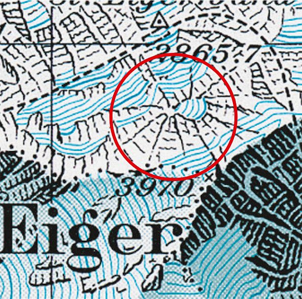
The principle that “Swiss maps simply show what’s there” has since applied again. Is Swisstopo by definition the distinctly humourless corner of the federal administration? On the contrary, it is a place of skilfully crafted jokes. If you look very carefully into the past, you may discover some rather whimsical little details. A white spider suddenly appeared on the side of the Eiger on the topographical map of the Interlaken region in 1981. Swisstopo cartographer Othmar Wyss had the audacity to incorporate this artistic detail based on a snowfield of the same name that is much feared by mountaineers. In the same year, the face of the “Hardermannli” – a rock formation resembling a human face – appeared on the south face of the Harder Kulm mountain near Interlaken. Shortly afterwards a mountaineer could be seen scrambling up a steep ridge near the Flüela Pass in the Swiss-Italian border region.
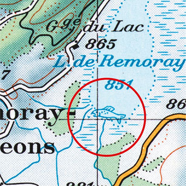
The very observant also found themselves rubbing their eyes in disbelief in 1983. A fat trout was so skilfully hidden from the proofreaders on the topographical map of Vallorbe in the wetlands of Lac de Remoray that it remained undetected. It was not until 1989 when the map was updated that the fish drawn by the cartographer Werner Leuenberger was plunged back into the depths of the lake. In 2011, the cartographer Paul Ehrlich, who specialises in the depiction of rock formations, found a good hiding place for a solitary marmot near to the Aletsch glacier. The animal remained undiscovered for years. Swisstopo is now faced with the delicate question of whether the furry animal can remain on the new edition of the map planned for 2019 given the federal office’s duty to depict reality as far as possible. The decision is keenly awaited. Five such jokes by cartographers have become public thus far. The history of Swiss cartography dates back 185 years. That means 0.03 pranks a year. A matter-of-fact, serious approach still predominates at Swisstopo.
Map extracts reproduced with the consent of swisstopo (BA170143)
From Dufour to Siegfried
The engineer Guillaume-Henri Dufour (1787 to 1875) from Geneva was commissioned by the Swiss Confederation in 1832 to produce the basis for a detailed map of Switzerland. In 1838, Dufour opened the Federal Topographical Office in Geneva. The Federal Office of Topography (Swisstopo), which emerged directly from it, is therefore Switzerland’s oldest federal office, older even than the modern federal state which was established in 1848. The individual pages of the “topographical map of Switzerland” were published on a scale of 1:100,000 from 1845 to 1865. These “Dufour maps” were the first official set to cover all of Switzerland. Dufour’s successor Hermann Siegfried (1819 to 1879) refined and perfected the style of Swiss maps. The “Siegfried maps” were characterised by contour lines, outstanding rock representations and light from an oblique angle.
www.swisstopo.ch; www.tiny.cc/Zeitreise; www.atlasderschweiz.ch


Comments
Comments :
Schade, als geborene Engadinerin bin ich enttäuscht zu lesen dass in einem Artikel über Geographie der Schweiz, der Flüelapass im 'schweizerisch-italienischen" Grenzgebiet enden soll. Aufklärung; der Flüelapass ist ein Bündnerpass von Davos nach Susch im Unterengadin. Danke
(Such cartographic jokes transcend national boundaries; the UK's Ordnance Survey has a few as well.)